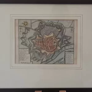
Caspar Merian was one of the most important topographical engravers and publishers of the Baroque period. From the important work Topographia Germaniae Inferiors etc., a total of 30 volumes appeared with 2142 perspective images, simple maps (mostly without street layout) and 92 maps.
- illustration: fortification map of Gouda, with the city’s coat of arms at top left, German legend 1-10 at top right. Bottom left a scale stick: 480 pedes geometrici. Appeared in Topographia Germania Inferioris (1659)
- year: ca. 1654
- quality: excellent
- signed: no
- image size: 18.6 x 26.8 cm | 7.3 x 10.6 in (h x w)
- sheet or frame size: 40.8 x 48.0 cm | 16.1 x 18.9 in (h x w)