As was common in those days, Hendrik de Leth had many trades. In addition to being an engraver, he was a printmaker, etcher, mapmaker, draughtsman, bookseller, art dealer, publisher and he collected art and naturalies.
He learned the trade of engraver and publisher from his father Andries de Leth (1662-1731). Andries took over the Amsterdam printing house after the death of the widow of Nicolaes Visscher II (a famous publisher and printer’s family of nearly a century) in 1726. He died five years later and Hendrik continued and expanded the printing business.
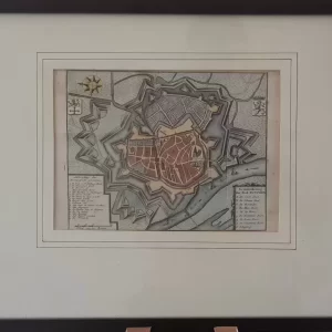
- Image: very fine hand-colored copper engraving of the city of Nijmegen, south facing map. Below a scale stick in rods; most likely the Rhineland rod (3.767 meters). Different lengths for rods were in use in the Netherlands. Top left a legend with all the names of the Nijmegen fortress. Top right a legend with names of squares and buildings within the fortress.
- year: 1740
- quality: excellent
- signed: no
- image size: 17.1 x 18.1 cm (h x w)
- sheet or frame size: 21.0 x 25.0 cm (h x w)