The famous Amsterdam publishing house Visscher was a producer of atlases, maps and (news) prints in the 17th century. The Visscher publishing house spans three generations: Claes Jansz. Visscher (1587-1652), Nicolaes Visscher I (1618-1679) and Nicolaes Visscher II (1649 – 1702).
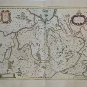
- Image: map of Friesland, Groningen, Drenthe and East Friesland.
Title in cartouche with compass rose and degree division in border, ships at sea and scale at lower right. Title: Tabula Frisiae, Groningae, et territorii Emdensis nec non circumjacentium regionum, puta
Transisalaniae, Benthemiae, Westphaliae et Oldenburgi ex officina N. Visscher - year: ca 1660
- quality: excellent
- signed: printed in plate
- image size: 43.1 x 54.1 cm (h x w)
- sheet or frame size: 52.2 x 62.2 cm (h x w)